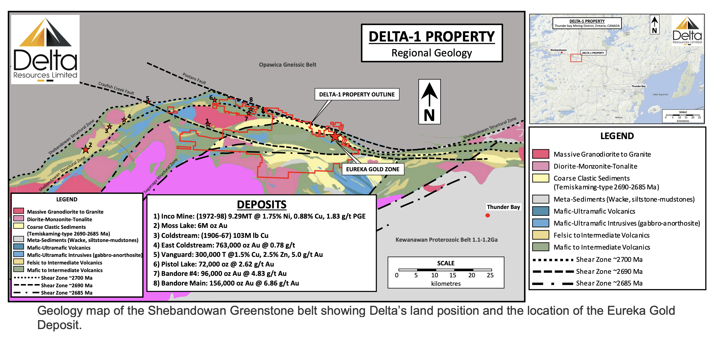
Property-Scale Gold mineralization
Eureka Gold Deposit:
Gold is hosted by a stockwork of quartz-ankerite-pyrite veinlets ranging from 1mm to 10cm in width. Multiple generations of mineralized veinlets are observed. Occasionally, fine grained disseminated visible gold is observed within the veinlets. The quartz-ankerite-pyrite gold veinlets crosscut every lithologies.
Lode-Gold-Type quartz veins of up to 4.5 metres in width as well as gold-bearing silica-flooding zones have also been observed within the deposit
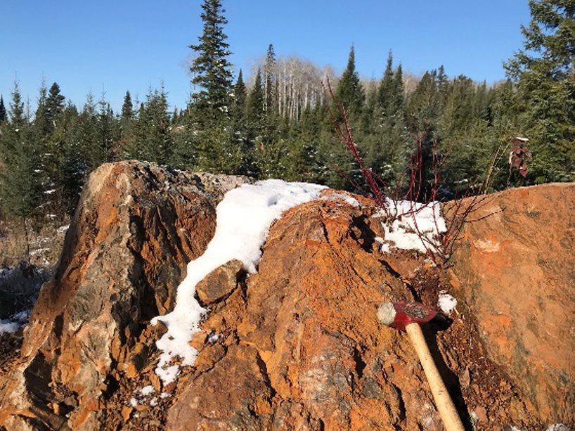
Host rock alteration consists dominantly of intense, texture-destructive ankeritization, silicification, albitization and sericitization combined with trace to 2% disseminated pyrite and trace arsenopyrite. At surface, rocks are weathered a dark rusty brown. The rock is massive, fine-grained, yellowish buff to pale grey with a common dusting of very fine-grained disseminated pyrite. Even without any veinlets present, the host rock typically contains highly anomalous gold.
Feldspar-phyric monzonitic to dioritic dikes are locally altered and are spatially associated with the gold stockwork.
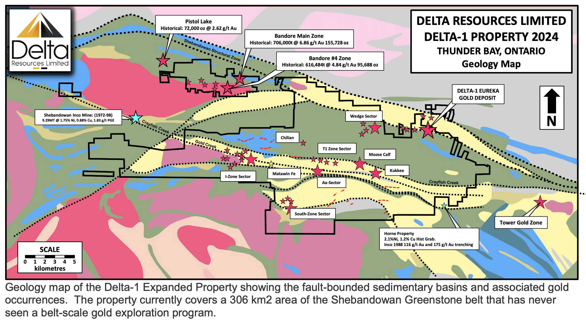
Band-Ore Main Zone and Zone 4:
At the Main Zone, gold mineralization is hosted by sericite rich, quartz injected shear zones with disseminated and stringer pyrite, hosted within a 300 metre wide unit of altered, sheared and variably mineralized felsic porphyry.
The No. 4 Zone was tested over a strike length of 500 metres and to a vertical depth of 200 metres only. Gold occurs in structurally controlled veins; quartz flooded zones and silicified pyritic tuffs.
The most recent resource estimates for the Main Zone and Zone 4 dates from the 1980’s by R.H. Clayton of Watts, Griffis and McQuat for Mattagami Lake Exploration. The estimated resource at the Main Zone was 778,000 tons grading 0.20 oz/ton gold per ton above the 500 foot level. At the No. 4 Zone the estimated resource was 616,484 tons grading 0.17 oz/ton gold.
*The historical resources stated here do not follow the required disclosure for reserves and resources as outlined in National Instrument 43‐101 as they were prepared in the 1980’s prior to the implementation of NI 43‐101 regulations. These estimates were executed prior to the introduction of National Instrument 43‐101; hence they should be treated as historical data and therefore not be relied upon.
Wedge, Chilian, T1, Moose Calf and AA Gold Occurrences:
Mineralization is similar in style as the Eureka Gold deposit, with gold being associated with a stockwork of quartz-ankerite-pyrite veinlets. Alteration also consists of ankeritization, silicification, albitization and a broad halo of potassic alteration.
Kasper, Mattawin, Kukkee Gold Occurrences:
Gold is hosted by horizons of sulphidic and graphitic chert, chert breccia iron formations. The rocks are ankeritized and silicified and characterized by an abundance of sulphide (dominantly pyrite with lesser arsenopyrite).
I-Zone Sector of Gold Occurrences:
At the I-Zone, as many as thirteen (13) gold bearing syenitic to granodioritic dikes were uncovered by INCO Gold between 1987 and 1989, over a strike length of 3.2 kilometres.
The mineralized dikes are 1-5 metres wide and some have been followed for up to 900 metres of strike length. Mineralization is typically associated with late NS-trending quartz veins up to 30cm wide.
The area has been tested by limited, near-surface grassroots-type drilling which returned intercepts such as:
- 3.28 g/t Au over 14.6 m; Inco Gold 1987-89
- 4.32 g/t Au over 41.0 m; Landore 1995-97
- 4.53 g/t Au over 14.4 m; Landore 1995-97
- 4.36 g/t Au over 20.4 m; Landore 1995-97
Inco Gold also carried out a bulk cyanide test on the mineralization and recovered 96.2% of the gold.
The last exploration work in the area was carried-out during the summer 2008, by Mengold Resources who collected a 1000kg mini-bulk sample on the mineralization and recovered grades of 9.9 g/t gold. The work was completed just before the financial crisis of 2008, and Mengold never returned to the property.
South Zone Sector:
The South Zone sector consists of tree (3) gold occurrences lying within 400 m of each other.
Gold mineralization is hosted by quartz-sericite-pyrite schist, cherty horizons and rhyolite breccias and is typically associated with base metals values such as copper and lead.
Mineralization at the South Zone appears to have gold-rich volcanogenic affinities similar to the Between 1988-1989, Inco Gold reported drill intercepts of 0.7 g/t Au over 39 metres and 1.63 g/t Au over 7.5 metres. Inco Gold also reported channel samples averaging 3.02 g/t Au over 2.43 metres over a strike length of 54.9 metres.
Gold mineralization at Delta-1 occurs as two distinct types:
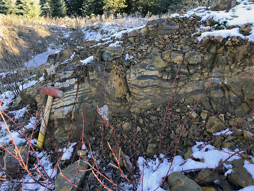
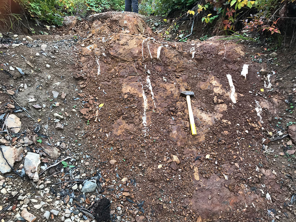
The Kasper, South, Creek and Mattawin gold occurrences are hosted by thin horizons of sulphidic and graphitic chert and chert breccia (perhaps sulphidic iron formations). At the Kasper gold occurrence, a banded iron formation is also observed. The rocks are ankeritized and silicified and characterized by an abundance of sulphide (dominantly pyrite with lesser arsenopyrite).
Kasper Gold occurrence. To the left, a sulphidic chert looking west (grab sample 8.72 g/t Au). To the right, the spatially associated banded iron formation at Kasper looking north (grab sample 0.08 g/t Au).
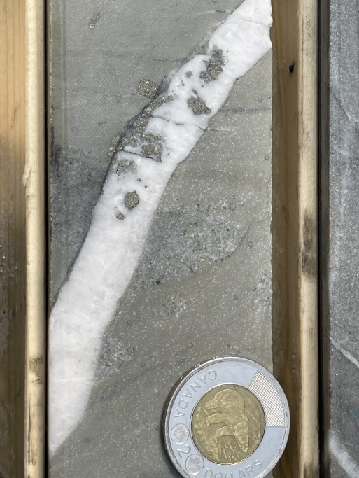
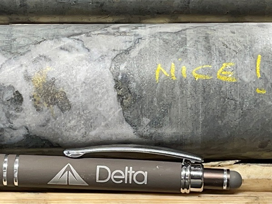
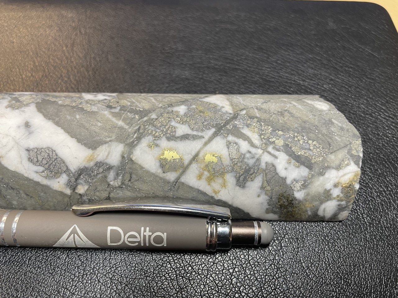
At the Eureka and Wedge Gold occurrences gold is associated with an organized stockwork of quartz-ankerite-pyrite veinlets ranging from 1mm to 10cm in width. Multiple generations of mineralized veinlets are observed. Occasionally, fine grained disseminated visible gold is observed within the veinlets. Although visible gold is dominantly associated with the pyrite at the walls of the veinlets specks of visible gold also occur in the central portions of the quartz veinlets.
In drill core, gold grade is directly proportional to the density of veinlets present. The presence of a single 1cm veinlet in the core can result in gold grades exceeding 1.0 g/t Au over a one metre interval.
Gold mineralization is late and the quartz-ankerite-pyrite gold veinlets crosscut every lithologies.
Host rock alteration consists dominantly of intense ankeritization, sericitization, albitization and silicification, with lesser sericitization combined with trace to 2% disseminated pyrite and trace arsenopyrite. At surface, rocks are weathered a dark rusty brown and rock textures are completely obliterated. In drill core and in fresh surface, textures of the sandstone, feldspar-amphibole-phyric intrusive and volcanics are locally recognized but typically also obliterated. The rock is massive, fine-grained, yellowish buff to pale grey with a common dusting of very fine-grained disseminated pyrite. Even without any veinlets present, the host rock typically contains highly anomalous gold. At Eureka, the extent of the alteration a mineralized halo containing 0.2 g/t Au to 0.4 g/t Au is defined over a minimum strike length of 1.5 kilometre and a true width of up to 187 metres.
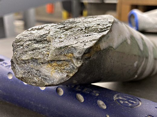
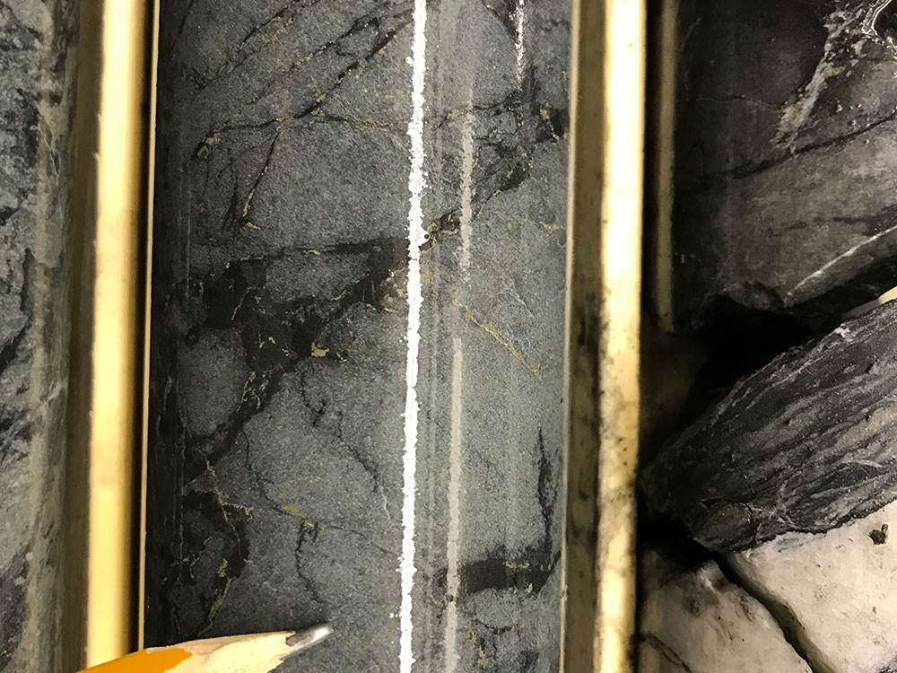
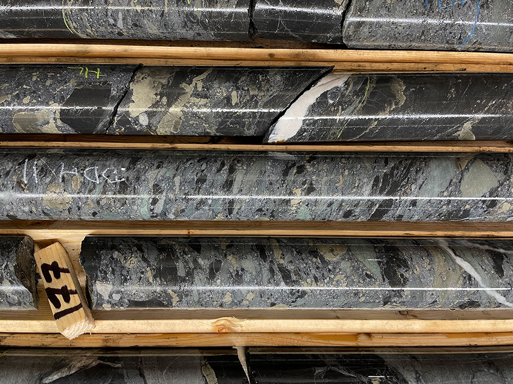
Gold Mineralization. Left: Quartz-ankerite-pyrite veinlet in sandstone from drill hole D1-21-10 at 79.9m. This single veinlet is responsible for an assay of 0.78 g/t Au over a 1 metre interval from 79m to 80m. Right: Quartz-ankerite-pyrite veinlet with visible gold in volcanics from drill hole D1-21-18.
REFERENCES
BAJC, A.F. 1999. Results of regional humus and till sampling in the eastern part of the Shebandowan greenstone belt, northwestern Ontario; Ontario Geological Survey, Open File Report 5993, 85p.
BROWN, G.H. 1995. Precambrian geology, Oliver and Ware townships; Ontario Geological Survey, Report 294, 48p.
COOKE, D.L. AND MOORHOUSE, W.W. 1969. Timiskaming volcanism in the Kirkland Lake area, Ontario, Canada; Canadian Journal of Earth Sciences, v.6, p. 117-132.
PARKER, D. 2020. Assessment work report on the Aurogen Project, Delta-1 Property. Mining District of Thunder Bay, Ontario, 40p.
ROGERS, M.C. AND BERGER, B.R. 1995. Precambrian Geology, Adrian, Marks, Sackville, Aldina and Duckworth townships; Ontario Geological Survey, Report 295, 66p.
STOTT, G.M. AND SCHNIEDERS, B.R. 1983. Gold Mineralization in the Shebandowan Belt and its Relation to Regional Deformation Patterns; in The Geology of Gold in Ontario, Ontario Geological Survey, Miscellaneous Paper 110, p.181-193.
GIRARD, R. AND BURDEN D. 2021. Report on an April 2021 Drilling Program at the Delta-1 Property, Thunder Bay District, Ontario, Canada. Shabaqua Area, Shebandowan Belt. IOS Services Géoscientifiques, 205p.
ROYER, G. 2007. Goldie Township Property Diamond Drilling Report, 112p.
TESSIER, A.C. 2022. Report on a November 2019 Drilling Program at the Delta-1 Property, Thunder Bay District, Ontario, Canada. Shabaqua Area, Shebandowan Belt. Delta Resources Ltd, 26p.
TESSIER, A.C. 2022. Report on an October 2020 Geological Mapping, Prospecting& Sampling Program at the Delta-1 Property, Thunder Bay District, Ontario, Canada. Shabaqua Area, Shebandowan Belt. Delta Resources Ltd, 26p.
TESSIER, A.C. 2022. Report on an April 2021 Drilling Program at the Delta-1 Property, Thunder Bay District, Ontario, Canada. Shabaqua Area, Shebandowan Belt., Thunder Bay District, Ontario, Canada. Shabaqua Area, Shebandowan Belt. Delta Resources Ltd, 35p.
WILLIAMS, H.R. 1991. Quetico Subprovince; in Geology of Ontario, Ontario Geological Survey, Special Volume 4, pt.1, p.383-403.
WILLIAMS, H.R., STOTT, G.M., HEATHER, K.B., MUIR, T.L. AND SAGE, R.P. 1991. Wawa Subprovince; in Geology of Ontario, Ontario Geological Survey, Special Volume 4, pt.1, p.485-539.